
The New 49’ers provide access to approximately 60 linear miles of gold-bearing mining properties. Most of this gold-rich property is located on the beautiful and scenic Klamath, Salmon and Scott Rivers, and their crystal-clear creek tributaries, near ,Happy Camp, California in the pacific northwestern section of the United States. We also have gold properties in Arizona. New 49’er management is responsive to members’ suggestions and needs. Because of our expansion, we have the resources to increase the number of mining properties as our membership grows.
GPS Coordinates for Individual Properties
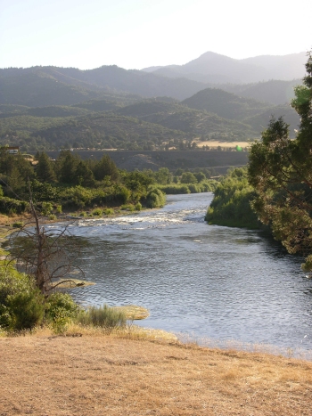
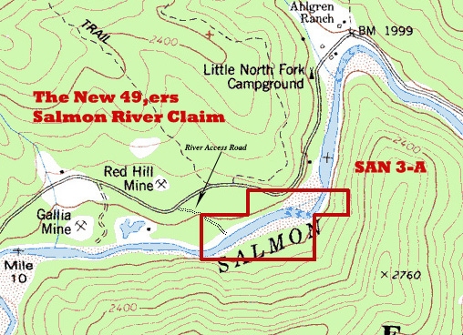
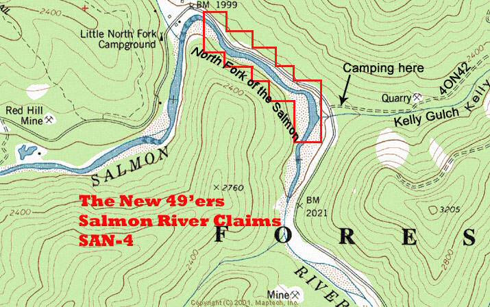
 PROPERTIES LOCATED NEAR HAPPY CAMP, CALIFORNIA: We now have access to 60 miles of gold properties near our Happy Camp facility. Approximately half of this region’s property is located on the Klamath, Salmon and Scott Rivers (in northern California near the Oregon border). About half is on the creek and tributaries to these rivers, not far from the small, but friendly, full-service town of Happy Camp.
Siskiyou County, where our Happy Camp headquarters is located, is one of the highest gold-producing counties in California’s golden history. However, because this area is several hundred miles away from the famous, but congested, Mother Lode area or any large cities, it has not been heavily worked by modern gold mining activity. The opportunity for successful prospecting is excellent.
During the past twenty summer mining seasons, literally hundreds of thousands of dollars in gold-value has been recovered by small-scale gold prospectors (mostly New 49’er members) from the Happy Camp vicinity. New gold strikes are being made on a continuous basis. Because of our abundant property reserves, the surface has barely been scratched. Most of these available mineral properties have yet to be seriously tested or mined by our members, and we are adding more proven mining properties on a routine basis. Our policy provides for growth: It is better to have more than enough mining properties and have them set aside for the future of our members!
Getting to Happy Camp is a bit of a drive for some people, but we feel it is far better for members to spend a few extra hours on the road to get to a proven gold-producing area, rather than to spend an entire vacation prospecting somewhere else and not recover any gold!
TYPES OF MINING PROPERTY: We have access to miles of beautiful creek property on the forks of Elk Creek, Indian Creek, Thompson Creek, the Scott River and the Main Stem & North Fork of the Salmon Rivers –all proven in their gold production. Depending upon the property location, water depth can be inches deep to five feet deep or more. Streambed material depth can be the same. There are some areas with a great deal of gold-catching bedrock showing. Gold deposits in creeks and small rivers tend to be more spotty and inconsistent than deposits along the Klamath River. Also, creeks and some areas of small rivers tend to yield more gold in the boulders. Creek prospectors should come prepared with boulder-moving equipment.
Along the miles upon miles of Klamath River properties, water depth can be from inches deep to 15 feet or more in some locations. Streambed material depth can be the same. We have an enormous amount of property available on the Klamath for all different types and sizes of operations.
While the Klamath is a fair-sized waterway, members and guests have found an abundance of mining areas suited for panning, mossing, sluicing (with and without motorized pumps), dry-washing, electronic prospecting and other types gold prospecting activity.
MINING & DREDGING SEASONS IN CALIFORNIA: The State of California recently passed a law which has placed a statewide moratorium on suction dredging in California until the Department of Fish & Game (DFG) completes an updated Environmental Impact Report (EIR) and completes several other requirements.
Just in case you do not know, this new law only stops suction dredging within 100 yards of California’s active waterways. It does not have anything to do with the other types of prospecting or mining that we do in California. Unaffected prospecting activities include panning, sniping & vack-mining, sluicing & high-banking, electronic prospecting and other types of prospecting that do not use a suction system to excavate material from the bottom of an active stream, river or creek. It also does not affect our group weekend projects.
There are no seasons imposed upon these other types of mining activity. In other words, you can do them at any time of the year.
Please be advised that these other types of mining activity along New 49′er properties are subject to our set of Surface Mining Operational Guidelines.
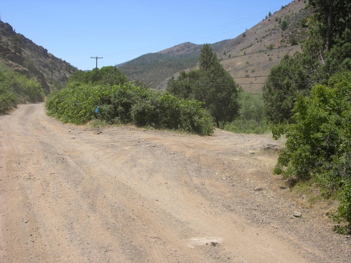
ACCESSIBILITY: Most of the gold properties available to our members are near roads which parallel them, and are reasonably accessible. Under most conditions, 4-wheel drive vehicles are not needed. However, some people do like to get off by themselves, and we have plenty of property which will fulfill their needs for solitude and serenity.
THE OTHER SIDE OF THE RIVER: There is a lot to be said for bringing a small boat or rubber raft along if one is available to you. To a large extent, the far side of the Klamath and Salmon Rivers have yet to be prospected and mined by our members. Some of the best finds these days from motorized sluicing, vacuum-mining and panning are coming from the far side of the river.
GUARANTEES: The Klamath and Salmon Rivers are very proven gold-bearing rivers. We recommend all beginning dredgers start on the Klamath, rather than on the creeks or smaller rivers. The Klamath’s consistent gold reserves guarantee that everyone is going to recover some gold if you get out and give it even the smallest amount of effort. We also recommend that above-water prospectors begin along our properties on the Main Stem & North Fork of the Salmon Rivers. Both sides of the Salmon are very consistent in gold both in the exposed moss and the surface gravels.
While some of our more experienced prospectors have done well on the creeks, and the creeks provide fantastic potential, people consistently do so well on the Klamath (dredging) and Salmon (mining alongside the river) that we find most of our members and guests end up prospecting on these rivers instead of the creeks.
Experience has shown that the key to successful gold prospecting is in learning how to prospect for acceptable gold deposits.
HOW SOME MEMBERS HAVE DONE: Prospecting operations on our gold properties usually fall into three general categories: Small-scale, intermediate-scale, and large-scale.
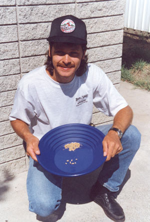
It is very common for our smallest-scale members to recover a pennyweight (1/20th of an ounce) or two of gold per day in their small dredging or shoveling activities. Some of our relatively new members have panned or shoveled as much as an ounce per week along our gold properties.
Our more experienced, intermediate-scale members can and do recover 1/4 ounce per day on a regular basis. Some of our individual members using sluices (using motorized pumps to provide water up on the stream bank) were averaging 1/4 ounce per day during a past season–even though one or two pennyweight per day is more common.
Not everyone recovers this much gold, but many of those who apply themselves to learning prospecting techniques have done this well and better.
Some of our more serious intermediate dredging members have averaged well over an ounce of gold per day at times. And some of our most serious, larger-scale dredgers (8-inch and 10-inch suction dredges along the Klamath River) have averaged in the multiple ounces per day range. Again, they prospected around to find higher-grade gold deposits.
It is common for people to ask us for average gold value figures contained within the gravels along the gold properties available to members. Placer gold deposits are not consistent enough to place an average figure on 60 linear miles of area! Some areas are great; some areas are poor; and some areas are in-between. How much gold you can expect to recover largely depends upon your level of ability and prospecting experience, size of equipment, how much work you are prepared to do–and partly on your luck. However, we feel a prospector largely creates luck by energetically undertaking proper sampling techniques. We can guarantee you are going to recover gold on the Klamath and Salmon Rivers. How much you recover depends entirely upon your approach.
We have had a fair number of members start from scratch and evolve their activity into lucrative small-scale, commercial mining operations. We have many success stories of this kind, and some members have done exceptionally well!
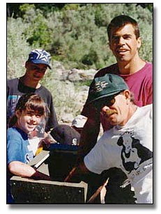
Since gold prospecting, like any other activity, has a learning curve, you need to study how to do it and get some experience under your belt to be continually successful. The New 49’ers have an ongoing program, which consists of organized group mining projects where we actually go out and do it, to help you with this. Generally, you can expect to do as well as you apply yourself to the available opportunities.
Just about all of our members agree that they have done better along our gold properties than elsewhere, and agree that there are no better gold opportunities available anywhere.
MINING PROPERTIES IN OTHER AREAS: The New 49’ers also have access to several quarter-section-sized mineral properties near Quartzite, Arizona. Using Happy Camp as a model, we are opening up property in Quartzite to create prospecting opportunities for our members during the winter months.
Most available gold properties are standard, non-patented, mining claims, but we do lease some private property mining areas. Some of the gold properties we use are owned by the Club or its Board of Directors. Some of them are leased. Some are located on State lands.
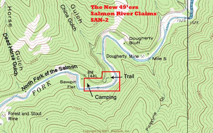
MAPS: We have detailed maps showing the location of all existing mining properties. Maps of newly-acquired properties are produced periodically as new areas are procured. The latest information about property acquisitions and other news can always be found on our website in the latest newsletters
MEMBERSHIP TRADES: We do on occasion accept quality mining claims in trade for fully-paid membership to The New 49’ers. Typically, these claims need to be in the same general areas where we are already established. They must be proven gold producers. Such trades are usually worked out on a trial basis, giving our members a chance to experience the gold potential before the trade becomes final.


