This issue is still available! Click here.
By Marcie Stumpf/Foley
“Boulders and huge logs slammed into homes, filling the insides and building up against walls until they caved in. Windows were blown out with the force…”
At the crest of flooding the Klamath River cut a wide swath along its banks, taking away scores of trees and anything else in its path. Flooding was especially devastating from Horse Creek to Happy Camp, a distance of 35 miles.
Many new creeks fed the rampant river as rainwater sluiced off the thoroughly saturated ground of every mountainside, raising the river up to even greater heights. As the runoff increased, hillsides along Highway 96 began giving way, as did mountainsides across the river. Rich red soil prevalent to the area was swept along with the river, creating a huge, churning mass of “chocolate milk.”
As the rains became heavier during the last few days of 1996, the situation became even more serious. A forecast of heavy rain for two more days, along with a large, forced release from Iron Gate Dam on December 31st, finished setting the stage for a disaster.
For the residents who live up Indian Creek and along the Klamath River, the last few days and nights of the year were so different, that many had a feeling of impending disaster and began to prepare for it. Leroy Hardenburger, a resident living along Indian Creek, reported that he could not even sleep for several nights before the flood, because the sound of huge boulders thundering down the creek became increasingly louder.
For residents living along the Klamath River, the roar of the river could not be quieted even by closed windows and doors. The rain kept coming in greater and greater amounts.
When warm rain melts snow, and rainwater exceeds predicted levels, the operators of Iron Gate Dam reach a point where they must release a great deal of water or risk losing the dam altogether, which would create a disaster of greater proportions. As in many cases in the west, there is no forewarning of dam releases in this area.
In Happy Camp, our first indication that the situation was becoming critical is when a report came over the scanner early in the evening of December 3lst that a motor home was stranded in 2-1/2 feet of water on the highway near Granite Point. This is a low area along the highway several miles upriver from Seiad Valley (about 25 miles upriver from Happy Camp).
Shortly thereafter, homes near the mouth of Indian Creek began flooding, and water and debris from a falls about 4- 1/2 miles up Indian Creek swept over the road.
Further news was spotty as it became impossible for Sheriff’s deputies to travel upriver further than Fort Goff. Slides along Highway 96 downriver from Happy Camp and on Indian Creek Road cut the town off by road from the outside world.
The river continued a steady rise through the nighttime hours. As light came with the first day of 1997, the rapid rise of water from an emergency release from the dam arrived along the mid-river area where Happy Camp is located. Many local residents did not sleep on that night of December 3lst. Every few minutes, cars were seen pulling into the nearest close view of the river (at my home) to check its level. Then, with the coming of daylight; the people of Happy Camp began showing up at homes which were located alongside the river. Uncalled and unasked, they brought trailers and trucks and pitched in to help, leading farm animals to higher land, removing furniture and belongings in the driving rain and rapidly rising waters.
It was all over within a few short hours, because the water quickly rose too high to proceed further with salvage from homes or property alongside of the river. Residents could only watch as the river swept away bits and pieces of their lives to join what looked like several forests full of trees that filled the middle of the river, racing with the swiftest current at the speed of a runaway freight train.
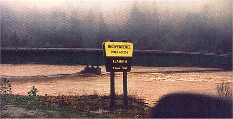
One of our members, Larry Ogborn, got stranded down by Independence for several days while successfully keeping his jet boat from being washed away by the storm. His is a very interesting story. Dave McCracken captured the following video segment during the early part of this storm, just before Larry got stranded down there. The video shows how much force Mother Nature can muster when she decides to:
All of the debris cleared under the local bridges near Happy Camp, however, and the rain began tapering off as New Year’s Day came to a close. The river reached its crest at approximately 1 a.m. on the morning of January 2nd, and residents were pleasantly surprised to find that the river and creeks had already subsided a great deal by daylight. While the river was not yet back into its channel, it had receded from most of the homes.
With Happy Camp completely cut off and the community’s water supply shut down because the pumps had been submerged, residents continued to help one another get through the first difficult days of the aftermath. Those on high ground with springs and good water supplied water for the many residents who were without. Other residents again began showing up at damaged homes with food, drink, crowbars and hammers, and helped remove ruined carpet and flooring as tons upon tons of wet mud was removed from homes. A local Americorps crew offered help in a great number of areas.
Many residents with riverfront property began the very substantial job of clearing the huge mounds of uprooted trees, logs and debris left behind by the rampaging river. California-Transit crews began work in more than a dozen critical areas along Highway 96, working long hours and bringing in extra equipment and trained personnel to repair the highway and access to it so that normal traffic could be restored.
Roads into Happy Camp were not open at all for almost a week, but the one remaining market and the restaurants continued to operate during that time, having food and other supplies flown in as necessary. The Community Services District set up a temporary system to provide water for Happy Camp, and samples were flown out for testing to make sure the water was safe for consumption.
It was several days before the community was even aware of the devastation to the Klamath River canyon and to homes further upriver. Because the highway was still closed on January 3rd, Jay Clark, Happy Camp’s postmaster, adventured a hair-raising four-wheel drive ride on primitive roads over the mountain crests to pick up and bring in around 5,000 pounds of mail. This was to help deliver much-needed income to local-area residents. That was the first mail the community had received since December 30th!
During the storm, one of the bridges across the Klamath River at Horse Creek was completely washed out. Further downriver, every small creek (O’Neil, Portuguese, Fort Goff, and Tim’s Creeks, just to name a few) became a torrent, carrying huge trees (sometimes as many as 20 or more) crashing down through the raging water, driving boulders and mud across Highway 96 along with them. At Portuguese Creek (as just one example), the drain pipe beneath the highway quickly filled and was blocked by trees and boulders. Buildup of material then began across the top of the highway. Soon, the roadbed was covered with 2-to-3 feet of mud, rocks, boulders and trees, and then covered with another 2 feet of water, for a distance of more than 300 feet of roadway.
In low areas such as Granite Point, the river eventually rose 10-to-15 feet above the Highway 96 roadway, peeling up the guardrail that bordered the highway around the curve and rolling it into an upward curl for more than 30 feet. One lane of the highway there was completely undermined.
Small creeks crossed the highway in many places where none had been before.
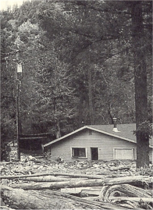 One of the homes bordering Walker Creek just upstream from Seiad Valley attests to the force of the creek at flood stage, which completely filled this home with debris and mud.
The most severe destruction to homes occurred in Seiad Valley where homes bordered Walker Creek. This creek roared through the canyon, sweeping aside all that came before it until it reached the homes along its banks and near the Klamath River. Boulders and huge logs slammed into the homes, filling the insides, and building up against walls until they caved in. Windows were blown out with the force of the deluge, and big logs were thrust through the sides of some homes.
The houses on the river-side of the highway were flooded at Fort Goff. The highway there was covered with a buildup of material from both the creek and the river, and the campground there was heavily damaged.
At savage Rapids, the corkscrew curves of the river forced the water to come up onto Highway 96, allowing water force to veer into the mountainside. It then swooped back around the curve and returned to the riverbed. An entirely new bed for the river was formed on the river-side of the road at the head of savage rapids, where the New 49’ers have a campground. There is now a forested island in the center of the river there
The access road is completely gone at the Seattle Creek River Access! You can make part of the first turn of the road that led down to the river, and then the access road ends in a huge mass of silt and sand.
Huge piles of jumbled trees at the mouth of Thompson Creek attest to the force that came down the creek. California-Transit crews have, been working for weeks to level off the piles of boulders and debris at its confluence with the Klamath River.
Anderson Campground has massive piles of trees which piled up against the few trees that remained standing in the campground. One camper that was left in the campground during the storm was tossed and battered around like a Tonka Toy. It finally came to rest wedged between trees near the lower-end of the campground. The camping area there was heavily damaged.
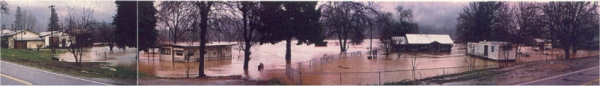
After crossing Cade Mountain and descending into the valley where Happy Camp is located, you find that the former New 49’ers headquarters building was under several inches of water. The mobile home located on the property had four feet of water inside. Our property (mine and my ex-husband Bill’s) had more than three feet of water and mud in the family room, and just over two feet of muddy water throughout the rest of the house.
Most houses located along Indian Creek near its confluence with the Klamath River were all flooded. More damage was done to other homes further upstream, because Indian Creek raised high enough to cross the road in a number of places. There was also damage done to homes on the far bank of the Klamath River below the mouth of Elk Creek.
Dave McCracken captured the following video sequence at the mouth of Indian Creek during the storm. Isn’t it hard to believe that is the very same quiet creek that we swim in during the summer months?
The river flowed up and through Curly Jack Campground (just downstream from Happy Camp) and damaged it.
The Klamath Inn Motel just downstream from Happy Camp was also flooded.
As the waters receded, I saw people rowing around in boats trying to salvage their firewood before it floated away. Many of us lost almost all of our firewood.
Residents who lived more than 6-1/2 miles up Elk Creek Road were “marooned” in their homes for 4 or 5 days, because the road was extensively undermined up there. A temporary detour has since been constructed, but there are a number of other areas of this road that have been damaged. The Club’s mining claim just above the Five-Mile Bridge has changed greatly. The camping area has been replaced by sand, mud and debris right up to the level of the road!
Elk Creek Road is in such unstable condition, that the USFS has installed a locked gate just above the Five-Mile Bridge until further repairs can be made. This is because they are concerned for the safety of the public.
The Club’s Chambers Flat camping area was completely underwater during the storm. Several feet of water also crossed Highway 96 there, causing the road to be closed at that point until just a few days ago. Further downriver in the canyon, slides and sinkholes are being worked on by California Transit. Although the road is passable, pilot cars are escorting traffic in several places.
Entire gravel bars along the Klamath River have been moved, leaving only boulders in their wake. Large deposits of sand and silt have been deposited in other areas where none existed before the storm. Bedrock is now visible in many locations where it was not present before. Some of the large bucket line dredge tailing piles located upriver have been either washed away or partially moved by the flooding. The river has been completely changed!
Several large gold nuggets have already been located in the Happy Camp area since the flooding. They vary widely in appearance, from rough and jagged, to one very smooth heart-shaped nugget that a local prospector showed me that was 8 pennyweights in size.
Members are reporting that it is a joy to prospect the banks of the river, because nearly all the blackberry bushes have been washed away. They are now able to get into bedrock crevices for sniping (and doing well) that they previously were unaware even existed. I saw one bottle almost full of nuggets and large chunks which one member found sniping along the banks of the river and creeks.
Jim Swinney, a local area nugget prospector, reports that it should be a great year. He usually finds about 20 ounces in gold nuggets each year on his time off from work. But he has already found more than 50 ounces this year with his metal detector!
Although this flood did not exceed the water levels of December 22, 1964, it came very close. It exceeded all other floods along the Klamath River since 1927, which was the earliest year that records were kept.
Since the flood waters receded in that first 24 hours, the river has been dropping a small amount each day. We have had a lot of calm and clear weather since the flood. There has been some rain and a few inches of snow the rest of the month; but as of mid-February, it has not caused additional problems.
There is no way to predict what the rest of this season has in store for this area; but even if no other rain should fall, the events that ushered in the new year have already made it a year that will go into the history books.
Note: Although our California-Transit crews have accomplished a great deal in a short time, there are still several areas along Highway 96 where some problems remain. We expect our efficient California-Transit crews will have those under control before long.
We are now looking forward to a great summer, with lots of fresh gold to be found!