Click on claim numbers for details and maps of the claims.
Click hereto see a high-resolution image of this map. (470,907 bytes)

Click on claim numbers for details and maps of the claims.
Click hereto see a high-resolution image of this map. (470,907 bytes)

To view the content from the coordinates links below you will need to have Google Earth installed on your home computer. Download Google Earth
Clicking on the individual claim number links will take you to the full description page for each claim.
Upper Klamath River:
UK-3: 41 52’15.4″N 122 33’32.8″W
UK-3A: 41 52’43.0″N 122 33’18.0″W
UK-4: 41 49’45.0″N 122 36’16.5″W
Main Klamath River:
K-1: 41 50’44.1″N 122 40’59.6″W
K-2: 41 51’23.0″N 122 42’8.4″W
K-2A: 41 51’31.3″N 122 45’1.5″W
K-3: 41 51’50.8″N 122 47’22.2″W
K-4: 41 50’9.7″N 122 56’35.4″W
K-5: 41 49’51.5″N 122 57’25.9″W
K-6A: 41 49’16.3″N 123 0’35.9″W
K-8: 41 47’15.8″N 123 4’46.1″W
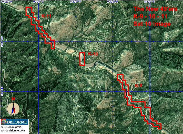
K-10: 41 48’36.0″N 123 6’56.3″W
K-11: 41 49’5.1″N 123 7’51.1″W
K-12: 41 50’10.5″N 123 10’31.3″W
K-13: 41 51’8.6″N 123 13’49.1″W
K-15A: 41 51’49.1″N 123 16’6.1″W
K-15: 41 52’7.6″N 123 17’6.3″W
K-16: 41 51’36.6″N 123 18’33.3″W
K-17: 41 49’14.6″N 123 18’8.1″W
K-17A: 41°47’54.21″N 123°19’4.95″W
K-18: 41 46’52.0″N 123 19’44.2″W
K-19: 41 46’10.3″N 123 20’18.2″W
K-19A: 41 47’30.4″N 123 20’48.0W
K-20: 41 48’30.00″N 123 20’58.3″W
K-21: 41 47’33.5″N 123 22’2.0″W
K-22: 41 44’42.4″N 123 24’5.1″W
K-23: 41 43’47.46″N 123 26’30.15″W
K-23A: 41 42’54.9″N 123 26’44.5″W
K-24: 41 39’45.1″N 123 27’0.2″W
K-24A: 41°39’9.72″N 123°27’38.75″W
K-25: 41 38’17.2″N 123 27’55.4″W
K-25AA 41°37’2.59″N 123°28’59.66″W
K-25A: 41 36’46.6″N 123 29’49.3″W
K-25AB 41°36’7.79″N 123°30’31.16″W
K-25B: 41 35’39.9″N 123 30’40.2″W
K-26: 41°34’51.01″N, 123°32’8.76″W
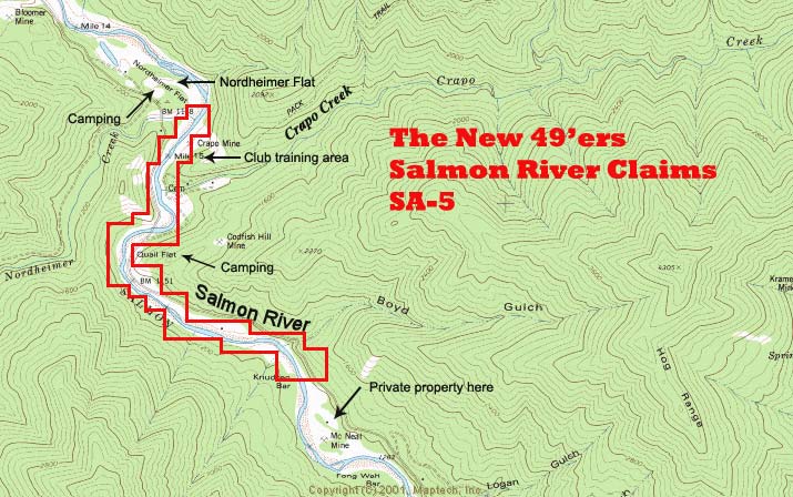
Main Stem, Salmon River:
SA-5: 41 17’5.2″N 123 21’36.7″W
North Fork, Salmon River:
SAN-1: 41 15’37.1″N 123 19’10.4″W
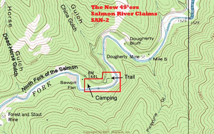
SAN-2: 41 16’42.9″N 123 16’1.1″W
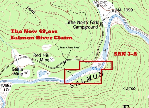
SAN-3A: 41 18’56.6″N 123 11’0.7″W
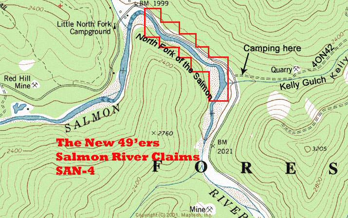
SAN-4: 41 19’5.8″N 123 10’17.5″W
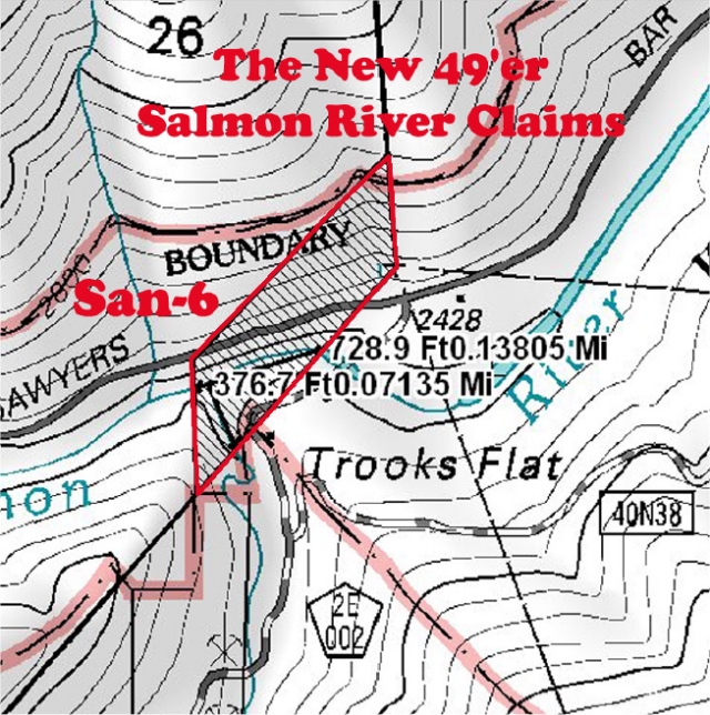
SAN-6: 41 17’57.2″N 123 4’59.2″W
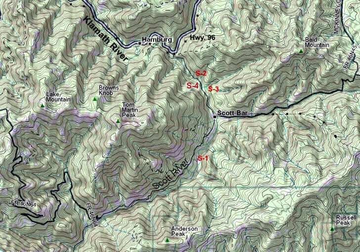
Scott River:
S-1: 41 43’56.0″N 123 0’30.9″W
S-2: 41 46’24.5″N 123 1’38.5″W
S-3: 41 45’10.7″N 123 0’35.0″W
Indian Creek:
I-1A: 41 51’47.9″N 123 24’10.0″W
I-1: 41 53’37.1″N 123 26’4.5″W
I-2: 41 54’37.5″N 123 26’59.6″W
I-2A: 41 54’59.10″N 123 27’59.10″W
I-3: 41 55’54.6″N 123 28’28.7″W
I-4: 41 52’32.1″N 123 26’20.2″W
Elk Creek:
E-1: 41 46’26.2″N 123 22’39.1″W (at top of road access)
E-2: 41 44’31.4″N 123 21’3.2″W
E-3: 41 44’41.4″N 123 21’21.8″W
E-4: 41 41’27.8″N 123 21’17.3″W
E-5: 41 39’30.1″N 123 19’5.2″W
Thompson Creek:
MAPS: We have detailed maps showing the location of all existing mining properties. Maps of newly-acquired properties are produced periodically as new areas are procured. The latest information about property acquisitions and other news can always be found on our website in the latest newsletters

| © 2013 | The New 49'ers Inc. P.O. Box 47 :: Happy Camp, CA 96039 :: (530) 493-2012 The New 49ers, all rights reserved. We appreciate your comments. Privacy Policy |
Information About the Club |
Learning Through Experience |
Camping & Lodging
Mining Properties | Events & Schedule | About the Area | What’s New Shopping | More About Gold | How to Find Gold | Gold Mining Adventures Message Forums | Legal & Political Affairs | Join | Contact | Links | Video Log-in Gold Mining Sampling and Consulting Services | California Gold Claims For Sale | Big Gold Nugget |
 |